ARC’s vision is to ensure that Appalachia — a region of great opportunity — will achieve socioeconomic parity with the nation. This means Appalachia’s economic indicators will become proportionate with the nation as a whole. While significant progress has been made, challenges such as economic transition in coal communities and the substance use disorder crisis remain.
Every year, ARC applies an index-based classification system to compare each county in Appalachia with national averages to understand how counties are performing. After analyzing three-year average unemployment rates, per capita market income and poverty rates, each one of Appalachia’s 423 counties is classified within one of five economic status designations: distressed, at-risk, transitional, competitive or attainment. The designations are also used to determine the match requirements for ARC grants, as well as research topics and investment strategies targeting resources to the region’s most distressed areas.
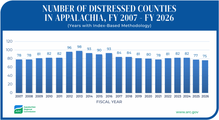
In fiscal year 2026, 75 counties are designated as distressed, 90 as at-risk, 240 as transitional, 14 as competitive, and 4 have reached attainment. Use the map to discover the economic status of counties and areas in Appalachia, or visit this web mapping application for more options.
Interactive Map of County Economic Status and Distressed Areas, FY 2026
Distressed Counties in Appalachia
ARC has been computing an index-based county economic classification annually since fiscal year 2007. While the number of distressed counties can fluctuate from year to year, the current number is the lowest level recorded in the 20 years of ARC’s index system.
Distressed Areas Within Counties
In some cases, specific areas within counties are considered economically distressed even if the county isn’t. ARC assigns the “distressed area” designation to census tracts in at-risk and transitional counties that have a median family income no greater than 67% of the U.S. average and a poverty rate 150% of the U.S. average or greater.